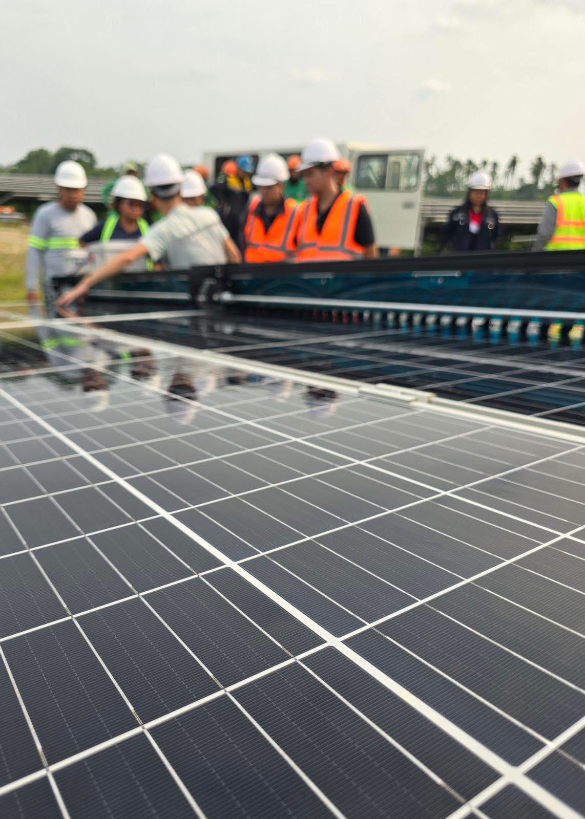
ABB Baldor-Reliance® HVAC Motors

Posted on
ABB Baldor-Reliance® HVAC Motors

ABB Baldor-Reliance® HVAC Motors

ABB Baldor-Reliance® HVAC motors are specifically engineered with industry-driven designs to keep air handling systems running smoothly, quietly and efficiently, which means better system reliability and performance with less maintenance.

We offer a complete line of HVAC motors designed to perform in the harshest applications while lowering total cost of ownership. We have motors available with integrated internal shaft grounding systems, motors for chiller/cooling towers, condenser and fan applications and more. We can also build custom versions of any stock motor we carry for specialized HVAC applications.

Features

Class F insulation, 1.15 service factor that operates within class “B” temperature limits at rated horsepower. Heavy-gauge steel frame construction, ball bearings, with plugged grease passages. Dynamically balanced rotors for reduced vibration and quiet operation. Suitable for mounting in any position. All models meet NEMA Premium®efficiencies, are inverter ready, and have a 3 year warranty. Includes bar-coded spec number label. Mounting holes on drive endplate enable field conversion to add Aegis shaft ground ring if desired.

Common industries

  • HVAC

Applications:

  • Heating
  • Ventilation
  • Air conditioning blower and fan motors

BRAAMD Inc. is a Channel Partner – System Integrator for ABB Motion Business. Contact us for your HVAC Motors and other low-voltage motors requirements.

Email: [email protected], [email protected], [email protected]

DJI Enterprise: Thermal Drones Applications

Posted on
DJI Enterprise: Thermal Drones Applications

DJI Enterprise: Thermal Drones Applications

  • Firefighting: One of the most common uses of thermal drones is as firefighting tools. Heat mapping from the air allows firefighters to get ahead of risk factors. When working inside structures, it’s possible to map out possible points of failure, while in wildfire scenarios, drones can help crews intercept fires’ progress in the open.
  • Search and rescue: Fires aren’t the only types of disasters where thermal drones can assist rescue crews. In the aftermath of catastrophes such as floods, landslides, earthquakes, tornadoes and hurricanes, thermal drones can help crews find missing victims, even at night. These thermal UAVs are also capable of tracking down individuals who have become lost in the wilderness.
  • Aerial utility and mine drone inspections: Inspecting utility infrastructure, from plants and solar panel installations to far-flung power lines, is easier with drones. Using thermal cameras alongside conventional imaging allows crews to watch out for potential failure risks in new ways, or even inspect the status of thermal panels. No matter how large a plant or mine is, drones can fly over the site and take readings.
  • Advanced agriculture: Monitoring crops and grazing herds from the air is a potentially overlooked use for drones. Thermal imaging lets farmers measure fields’ heat exposure and track animals, even at night. Ongoing efforts to make farming more efficient through technology deployment are a perfect match for drone deployment. 

Drone options: Find the best thermal drone for your purposes

While your choice of camera payload is important for thermal drone performance, so is the commercial drone chassis you pick. The right drone body will deliver the speed, maneuverability, service range, battery life and other traits that will determine what types of tasks your new thermal drone can accomplish.

The following are a few of the market-leading commercial drones you can choose from for your thermal deployment.

  • DJI Enterprise Matrice 30T Thermal Drone. The M30T is a tough drone chassis built to stand up to the elements and designed to be highly portable despite its impressive sensor payload. The control system for the M30T is especially advanced, with a 7-inch widescreen display on the dual-stick control system designed for enterprise drone pilot use. 
  • DJI Enterprise Mavic 3 Thermal Drone. See the Unseen. Mavic 3T’s thermal camera has 640 × 512 resolution and supports point and area temperature measurement, high temperature alerts, color palettes, and isotherms to help you find your targets and make quick decisions.
  • DJI Enterprise Matrice 350 RTK with Zenmuse H20T. Equipping the M300 RTK with a Zenmuse H20T or H20N as one of its payloads allows users to capture unprecedented levels of high-resolution thermal information. 

Unilyte Rangle VRLA Battery

Posted on
Unilyte Rangle VRLA Battery

Unilyte Rangle VRLA Battery – Ensuring longer service life for both standby & cyclic applications

EverExceed Unilyte range VRLA batteries adopt ultra high seismic resistance, can reach earthquake resistance level of 10. These batteries are constructed with the finest quality materials and state of the art manufacturing techniques, designed for standby & cyclic applications that require reliable power and long life.

EverExceed Unilyte Rangle VRLA Battery

What is RTK and what it means for your drone?

Posted on
What is RTK and what it means for your drone? With an RTK drone, surveyors and other enterprise drone pilots can expect centimeter-level positioning accuracy with each flight. The system represents a marked improvement from satellite data and can help ensure you have the accurate information you need to get the job done. Here's what you need to know about RTK

What is RTK (real-time kinematics) and what it means for your drone?

With an RTK drone, surveyors and other kinds of enterprise drone pilots can expect centimeter-level positioning accuracy with each flight. The system represents a marked improvement from satellite data on its own and can help ensure you have the accurate information you need to get the job done.

What exactly is RTK?

Real Time Kinematics, or RTK for short, is a special technique for satellite positioning that can produce accurate results to the centimeter, making it an invaluable tool for surveyors around the world. The method involves measuring satellite data against a ground station for precise, real time information.

The key parts of the RTK technique include:

  • A base station: The RTK GNSS base station, also known as a reference station, remains at a defined point on the ground, where its GPS location is continually contrasted with the location of a drone. In order to work properly, an RTK drone must stay in constant connection with the base station.
  • RTK receiver: This device is a part of the hardware of the drone and sends signals to both the controller and a satellite.
  • A controller: Your drone’s remote controller sends signals to move the drone and displays coordinate changes.
  • Satellite: Satellite data is still a key part of any RTK system. However, rather than simply communicating with the drone receiver, information is also tested against the base station, establishing position accuracy.

The RTK advantage

RTK GPS data is far superior to satellite data on its own because it can be used to correct inaccuracies and discrepancies, ensuring information hews as close to reality as possible. There are numerous factors that can skew satellite coordinates, including incremental weather, tall buildings, mountains, and other issues calling for RTK correction. These are called “tropospheric delays.” The RTK system fills in these gaps with real time data from the base station and drone.

The major benefits of an RTK system include:

  • Improved accuracy: This is the big one. When compared to satellite data alone, an RTK system offers high accuracy — typically down to centimeter-level.
  • Real-time corrections: While other adjustment technologies like PPK (more on that below) correct skewed data and fill in gaps after a flight is completed, RTK corrections fix errors automatically. This means that the data you see during a flight is data you can trust.
  • Fewer ground control points: Ground control points are set spots on the ground with known coordinates that can be used to readjust GPS data. Laying out and measuring these points can be time-consuming. However, with RTK, the base station makes GCPs moot, allowing you to complete projects with significantly less hassle.

The difference between similar drones with and without RTK is startling. In one recent study, DJI and DroneDeploy compared the Phantom 4 RTK and Phantom 4 Pro (a consumer edition that does not have a built-in RTK receiver) over more than 30 different flights with a control point system for a rooftop building survey. The results showed that the RTK-enabled drone calculated horizontal and vertical accuracy of the measured points better, as well as the accuracy of linear measurements.

Getting the most out of your RTK hardware

If you’re looking for an RTK system that’s reliable for each and every flight, you’ll want an enterprise drone from DJI. Our RTK systems utilize an on-drone module and a high-precision GNSS Mobile Station. The combination of onboard RTK receiver and GNSS signal reference station delivers a high degree of RTK accuracy. Whether you elect to rely fully on RTK or also have PPK capabilities as a backup, using a DJI drone means you can expect to stay connected no matter the mission.

Some of DJI’s premier RTK drones include:

DJI Matrice 30

DJI Matrice 30 Enterprise Drone

The Matrice 30 takes everything the Matrice 300 has, and packs it into a portable package. With a smaller footprint and weight, the Matrice 30 is far easier to take along for your inspection missions. With built in RTK modules, it’s the perfect solution if you need to conduct precise drone inspections of assets or infrastructure that require centimeter-level accuracy.

DJI Matrice 350 RTK

DJI Matrice 350 RTK
DJI Matrice 350 RTK

Welcome to the future of commercial drones. The Matrice 350 RTK accentuates its advanced RTK positioning system with advanced AI capabilities and six directional sensing positioning. Add in a 55 minute maximum flight time, hot-swappable batteries, and a wide-ranging operating temperature and you get a drone that’s ready for any job you can throw at it.

DJI MAVIC 3 ENTERPRISE SERIES

DJI Enterprise Drones Mavic 3M

The Mavic 3 Enterprise Series redefines industry standards for small commercial drones. With a mechanical shutter, a 56× zoom camera, and an RTK module (sold separately) for centimeter-level precision, the Mavic 3E brings mapping and mission efficiency to new heights.

Source.

QYSEA Fifish V-EVO Special Features

Posted on
QYSEA Fifish V-EVO Special Features

QYSEA Fifish V-EVO Special Features

166° Ultra Wide-angle Viewing & Recording

See the bigger picture and discover an extraordinary world below. Go beyond a conventional underwater lens to achieve a greater impact with your visuals.

Real-time Color Balance & Image Enhancements

QYSEA’s self-developed and adaptive imaging system lets you see the underwater world in its true vivid colors, with dynamic reduction of noise reduction. Maximize your underwater vision with FIFISH V-EVO, wherever your dives take you.

Adaptive AI Sea Plankton Filtering Algorithm

Using intelligent imaging algorithms, FIFISH V-EVO naturally filters out white marine flakes caused by plankton and bacteria. Create your cinematic shots with maximum smoothness and clarity.

5000 Ultra-bright Lumen LEDs

FIFISH V-EVO comes equipped with a pair of combined 5000 lumens · 5500K white LED lights. Optimize your vision across the deep sea and restore the colors of the world below, especially through dark and turbid environments.

Move & film with absolute freedom underwater

Reach beyond the limits of traditional methods, achieve full 360° freedom in underwater mobility, hovering and posture holds. Turn your creative imagination into cinematic 4K imaging reality.

Order your FIFISH V-EVO Underwater Machine here.

DJI Enterprise Drones Applications in Mining

Posted on
DJI Enterprise Drones Applications in Mining

DJI Enterprise Drones Applications in Mining

HAUL ROADS

An efficient haul road network is crucial to a successful mining operation. A mine’s structure constantly changes, meaning haul roads need to be regularly corrected and optimized to maintain productivity and safety. Drones can gather a considerable amount of aerial data, accurately mapping large areas, so engineers can plan and construct safe and uniform haul roads which can then be continually monitored.

HAZARD IDENTIFICATION

Mining sites are complex and can be dangerous, so workers’ safety is a priority. Drones enable surveyors to identify errors, possible dangers and weaknesses faster. A drone’s capabilities, the use of high-resolution and thermal imaging, can detect faults or potential hot-spots that can be rectified before they cause delays or accidents.

SITE SECURITY

Protecting mining equipment, property, and resources is an important, yet challenging task. Drones are able to secure perimeters and safeguard equipment, detecting suspicious activity and alerting security staff. Being airborne is also advantageous when coordinating with emergency services if they are required, by safely directing response vehicles around the site.

STOCKPILE MEASUREMENTS

A significant challenge for mining companies is to manage the stockpiles, where volumes are large and regularly change. Drones enable mining operators to produce aerial terrain models of their inventory so they can efficiently manage and oversee stockpile movement. These models can be generated with little effort and without the need for highly trained operators.

Increase savings for your internal inspections? Use Elios Drones.

Posted on
Increase the efficiency and safety of Cement Industry operations with the Elios 3 drone

Increase savings for your internal inspections? Use Elios Drones.

How can you increase savings for your internal inspections?

By using ELIOS indoor drone to reduce downtimes, eliminate the need for scaffolding, and reduce the amount of labor required.

  • Minimizing loss of production during internal inspections by reducing turnaround times can have a huge impact on savings, since many industrial facilities lose hundreds of thousands or even millions of dollars for every day that they are one.
  • Eliminating scaffolding, cranes, and rope access can save you tens or even hundreds of thousands of dollars per inspection by avoiding the cost of materials and the labor required to build and take down a temporary structure—not to mention the extra downtime these efforts require.
  • Reducing the labor needed for an inspection, both in terms of total hours spent and in terms of the number of people needed on the job site, can also have a big impact on savings for each inspection.

Let’s make these savings concrete.

  • Marine Inspection Services, Ltd. helped an oil tanker manager realize two million dollars in savings using Flyability’s Elios for a cargo tank inspection. The savings primarily came from avoiding the need for scaffolding—building and taking down the scaffolding would have cost $400,000, and the extra time that work required would have cost $1.6 million in downtime for the oil tanker.
  • Pampa Energia realized $320,000 in savings from a single inspection flight with an Elios drone. Here the savings also came from avoiding the need for scaffolding—the scaffolding would have cost $30,000 and the extended downtime to build and take it down would have cost $290,000.
  • AEROVISION Drone Support GmbH helped a paper mill realize 960,000 € in savings using the Elios for a tank inspection. All of these savings came from reducing the downtime of the tank, which lost 480,000€ for every day it was one.

These savings are not unique to a specific industry or type of inspection. Across industries, you can realize significant savings by using an indoor drone to reduce downtimes and eliminate the need for scaffolding in your internal inspections.

Improve Safety Using Industrial Inspection Drones

Posted on
Improve Safety Using Industrial Inspection Drones

Improve Safety Using Industrial Inspection Drones

How can you improve safety for your internal inspections?

By using an indoor drone to eliminate or significantly reduce the need for inspectors to enter confined spaces to collect visual data.

  • Every year in the U.S. 200 people die and 15,000 people are seriously injured while working in confined spaces, according to OSHA.
  • Every year in the U.S. about 4,500 people are injured and 60 killed due to accidents related to working on scaffolding, according to OSHA.
  • From 2017 to 2019 there were 28 serious injuries as a result of people using rope access in industrial settings, four of which were fatal, according to the global Industrial Rope Access Trade Association, which is based in the U.K.

It’s worth noting that these confined space and scaffolding statistics are just for the U.S. If you apply these numbers globally, it’s likely that there are thousands of deaths and tens of thousands of injuries every year associated with the work inspectors do in confined spaces. Death and injuries that could have been prevented using Elios inspection drone. Instead of entering confined and hazardous spaces themselves, inspectors can use an indoor drone to collect visual data, allowing them to remain safely outside.

Improve Safety Using Industrial Inspection Drones, contact us to learn more.

Reduced Downtimes Using Elios 3 Drones

Posted on
Reduced Downtimes Using Elios 3 Drones

Reduced Downtimes Using Elios 3 Drones

How can you reduce downtimes for your internal inspections?

By using an indoor drone to eliminate the need for scaffolding and to speed up your data collection.

Scaffolding can take several days to put up and take down, adding dozens of hours of downtime to the internal inspection process. Indoor drones eliminate the need for scaolding by taking the place of inspectors in collecting visual data.

Speeding up data collection can have a big impact on reducing the total turnaround time needed for an internal inspection. Indoor drones can get full coverage of an area much more quickly than an inspector can by walking or climbing in the same area, all while retaining a high standard of data quality.

Preparation for confined space entry can be time-consuming, requiring work permits, the presence of rescue teams on site, and other preparatory work that using an indoor drone can help avoid.

Indoor drones have the potential to reduce the total amount of time needed for an internal inspection by 90% — or more.