DJI Enterprise Drones and Solutions for Wind Turbine Inspection

Posted on

Traditional Challenges in Wind Turbine Inspection

Operations need to be paused for inspections, where cranes lift personnel high up to get close to the blades and record observational data, which is risky and time-consuming. Inspection data are qualitative records that might not be digitized, which can cause issues in recordkeeping and takes longer from inspection to repairs.

How Drones Inspect Wind Turbines

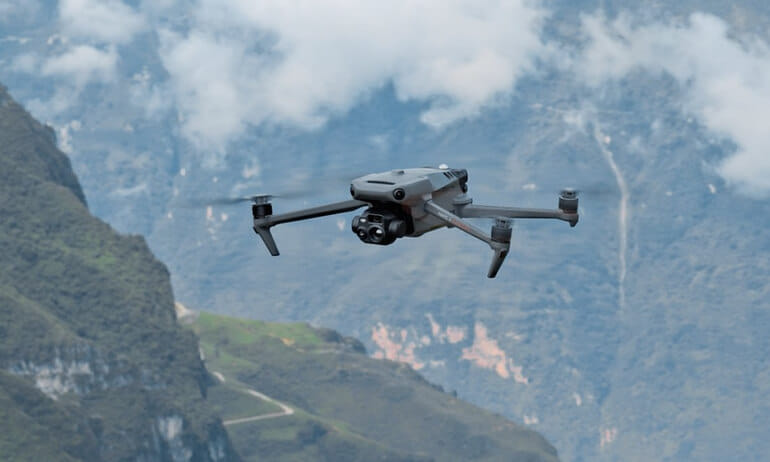
Automated flight routes can be set up to conduct thorough, repeatable inspections of the wind turbine without safety risks to personnel. Drones can get close-up images of defects on the blade such as cracks, water ingress, corrosion or rust with a zoom camera without shutting down operations. Drone inspection results are quantitative and digitized, facilitating data analysis and recordkeeping.

We offer enterprise and industrial drones with value-added training plus year-round support to our clients. Please contact us at [email protected] or [email protected] to inquire.

Dwyer: Series 490W Wireless Hydronic Differential Pressure Manometer

Posted on

Dwyer’s Series 490W Wireless Hydronic Differential Pressure Manometer is the most accurate and easy-to-operate manometer on the market. Along with wireless transducers and a mobile device, a single operator using a 490W can monitor and balance a hydronic system in less time and with less manpower than would be possible using a traditional hydronic balancer. In addition, being wireless, the 490W has zero hoses or manifolds – meaning there are no annoying attachments that need to be carried, that can snag onto equipment, or that need to be drained between readings.

To see full specifications and to request for a quotation, please click below:

3D Level Scanner with IECEX/ATEX Approvals

Posted on
3D Level Scanner with IECEX/ATEX Approvals

3D Level Scanner with IECEX/ATEX Approvals

Get more accurate inventory with the only level sensor that measures and maps multiple points on the material surface.

Software creates a 3D image of the topography inside the silo. 3DVision software accounts for irregular material surfaces when calculating volume.

Dust-penetrating, non-contact technology ensures reliable measurements in solids and powders, including low dielectric materials.

It has IECEx/ATEX approvals. And you can get it only from BinMaster and Braamd Inc.

Email: [email protected], [email protected].

Demo of ELIOS 3 with UT Payload for Maritime Applications

Posted on

A quick video of demo showing how quickly the E3 + UT can be deployed and measure thickness in maritime applications. With Elios 3 and its payload, measure thickness and do up to 40 UT scans in every 10 minutes. For cargo and tank inspections, Elios 3 is up to 10X Faster than traditional methods.

Built from the start to perform contact inspections, the Elios 3 is the ideal tool for close-up visual inspections and UT measurements even in confined and gps-denied areas. The UT payload developed in collaboration with Cygnus Instruments allows the drone to perform accurate ultrasonic thickness measurements on vessels and other maritime equipment. Elios 3 UT provides you with all the data needed for a CLASS inspection while leaving inspectors safely on the ground and saving you significant time and money.

Benefits:

Safety. Avoid personnel working at height or in confined spaces by performing remote drone inspections even in GPS-denied areas

Efficiency. Reduce costs by up to 90% by avoiding scaffolding and rope access Inspect in a team of just two and capture UT measurements 10x faster.

Downtime. Slash downtime by up to 80% and inspect even while on anchorage. Always have an inspection tool at hand to never waste time.

Please contact us to request for Elios 3 demo or for Philippine pricing.

The DJI Zenmuse H30T is designed to support side-by-side zoom and infrared thermal camera monitoring

Posted on
The DJI Zenmuse H30T is designed to support side-by-side zoom and infrared thermal camera monitoring

Critical Cooling motors reliably increase uptime and decrease maintenance of critical HVAC applications in data centers, hospitals and commercial and industrial buildings Critical Cooling motors are designed for inverter duty with either NEMA Premium® (IE3) or ultra-premium (IE5+) efficiency levels. When used with variable frequency drives, Baldor-Reliance Critical Cooling motors offer the highest level of bearing protection in the industry with a lifetime warranty against bearing failure from shaft currents.

To learn more about Critical Cooling Motors, please contact us at [email protected] or [email protected]. You may also visit our website at www.braamd.com.

Gorman-Rupp 10 Series® Pumps

Posted on
Gorman-Rupp 10 Series® Pumps

Gorman-Rupp 10 Series® Pumps

Gorman-Rupp 10 Series® pumps are specifically designed for handling solids, corrosive liquids and slurries. They have few moving parts, so maintenance is minimal. If a clog occurs, it can be removed easily through the cover plate opening without disturbing piping or the use of any special tools. The 10 Series offers a variety of metallurgy and seal configurations to choose from to handle a number of different liquids.

Quick Specs:

  • Size: 1-1/2″ (40 mm), 2″ (50 mm), 3″ (80 mm), 4″ (100 mm), 6″ (150 mm), 12″ (300 mm)
  • Max Capacity: 6700 GPM (423 lps)
  • Max Head: 130′ (40 m)
  • Max Solids: 3″ (76 mm)
  • Max Temperature: 160 F (71 C)
  • Materials of Construction: Bronze, Cast Iron, CD4MCu, Stainless Steel

For Gorman Rupp pump requirements, spare parts and projects in Philippines, contact Braamd Inc.

ABB’s Baldor-Reliance® Critical Cooling Motors

Posted on

Critical Cooling motors reliably increase uptime and decrease maintenance of critical HVAC applications in data centers, hospitals and commercial and industrial buildings Critical Cooling motors are designed for inverter duty with either NEMA Premium® (IE3) or ultra-premium (IE5+) efficiency levels. When used with variable frequency drives, Baldor-Reliance Critical Cooling motors offer the highest level of bearing protection in the industry with a lifetime warranty against bearing failure from shaft currents.

To learn more about Critical Cooling Motors, please contact us at [email protected] or [email protected]. You may also visit our website at www.braamd.com.

DJI Terra: FAQ’s Answered

Posted on
DJI Terra: FAQ's Answered

DJI Terra: FAQ’s Answered

DJI Terra is popular all-in-one drone mapping solution, to understand it better, read top FAQ’s to see how it can improve your 3D modeling experience.

  1. What is DJI Terra, and how is it integrated with DJI drones? DJI Terra, a 3D model reconstruction software, is a solution that efficiently processes aerial image data captured with DJI drones. It swiftly converts this data into high quality and accurate digital maps that are easy to understand. It also enables users to transfer and process their digital maps quickly and efficiently. This integration enables you to harness the full power of your data sets, whether you’re in surveying, construction, agriculture, or other industries. With DJI Terra, you can expediently and effectively transform your drone-captured data into actionable insights, adding significant value to your business or work in these industries.
  2. Can DJI Terra output data in standard formats for easy application integration? Absolutely. DJI Terra supports various standard formats, such as TIFF orthomosaic, LAS point cloud, DXF, and several 3D model formats. This compatibility makes integrating DJI Terra’s output data with other software you might use, like GIS (Geographic Information Systems) or CAD (Computer-Aided Design) applications, accessible.
  3. Can DJI Terra output data in different coordinate systems? DJI Terra offers over 8500 built-in common coordinate systems, allowing users to select a system by name or EPSG code. Additionally, it supports the import of PRJ files and the use of seven-parameter transformations to customize coordinate systems. This flexibility simplifies the integration of data with various GIS, CAD, and other third-party data application software. DJI Terra’s capability to handle different coordinate systems enhances its usability for various drone data industry applications.
  4. Can ground control points (GCPs) be used to process LiDAR data in DJI Terra? Yes, DJI Terra supports the use of Ground Control Points (GCPs) to improve the elevation accuracy of LiDAR data. You can also import Check Points to verify the accuracy of your LiDAR data. This feature is especially valuable for projects that require high precision, such as topographic mapping and infrastructure monitoring.
  5. Can Zenmuse L1 & L2 raw data be processed without an RTK connection? Can the same data be processed during a regular GPS flight? Yes, you can process both Zenmuse L1 and Zenmuse L2 raw data without an RTK connection using a method called post-process kinematic (PPK). You’ll need to add a base station observation file (such as Rinex, RTCM, OEM, or UBX) and additional raw data to the L1/L2 raw data folder. This ensures you get accurate point cloud files without a direct RTK connection during a flight.
  6. Can I share my output files from DJI Terra? Yes! DJI Terra makes it easy to share your output files. Through DJI Modify, you can create a URL link and share it with other team members, clients, or stakeholders. This new feature streamlines collaboration and ensures that everyone involved has access to the latest data for better-informed decisions and planning.

      More FAQs here.

      QY-BT (QYSEA Bathymetry Tool) by QYSEA Technology – VIDEO

      Posted on
      Smart Measurement & Bathymetry Survey with FIFISH AI ROV QYSEA Technology

      QY-BT (QYSEA Bathymetry Tool) by QYSEA Technology is a specialized intelligent water depth measurement tool designed to enable precise 2D and 3D topographical mapping of the, enabling real-time display of contour lines and depth data, calculates reservoir volumes, and performs underwater depth mapping tasks safely, efficiently, and cost-effectively. Essential features include: Features: Rapid export of visual data to the system Multiple dynamic modes of measurement Clear & intuitive interface to, simplifying complex subsea measurement tasks We have more info, and product/package cost of this. Please contact us to discuss. Email: [email protected], [email protected]